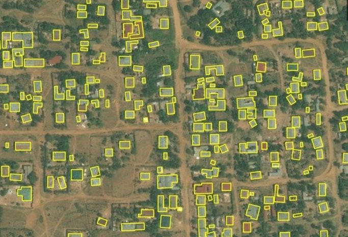
When disaster hits, be it a natural disaster, epidemic, poverty or other crisis, first responders rely on GIS data to access the areas impacted.
 Missing Maps is an open-source collaborative effort founded by the American Red Cross, British Red Cross, Medicine Sans Frontiers, and the Humanitarian OpenStreetMap team where volunteers help to map areas in an effort to ensure that many of the places previously missing from maps can be located and reached.
Millions of edits are made to OpenStreetMap by thousands of volunteers and members of the OpenStreetMap community.
How Missing Maps Works
Missing Maps, which was funded by large humanitarian organizations like the Red Cross, operates very simply. The collaboration process essentially involves just three steps:.
- Volunteers use OpenStreetMaps to trace relevant imagery. This could involve anything from unnamed roads that connect villages to disaster-prone buildings in hazardous areas.
- Community volunteers working in the field add to the traced imagery by offering local details like road names and community shelters.
- Once these zones have been mapped out, humanitarian organizations can quickly work towards disaster prevention and mobilize aid as needed.
Even users who have never mapped before can quickly get the hang of Missing Maps, thanks to the numerous text-based and video tutorials provided on their website. The project also constantly strives to encourage new volunteers to join the effort with fun, regular mapathons targeted at different areas. Anyone can lead their own mapathon, and it’s a great place for beginners to quickly get the hang of things.
Humanitarian mapping with Building Footprints
Moved by the Missing Maps objective, “To map the most vulnerable places in the developing world, in order that international and local NGOs and individuals can use the maps and data to better respond to crises affecting the areas,” teams at Microsoft are contributing time, resources and technical expertise to the project.
Investment in Missing Maps from organizations like the Red Cross is being supplemented by advances in technology, including strides in AI and high-res mapping. For example, Microsoft has been updating and releasing new building footprint data to power the community mapping initiative. Progress with these releases has been steady, with over 50.5 million building footprints being identified in Kenya and Nigeria alone. The community has access to this data under an open license, removing the hassle of bureaucratic red tape and promoting fast-paced community mapping.
Building footprints are useful tools for identifying disaster-prone buildings for Missing Maps and other map features. The Bing Maps API team used AI-assisted mapping to achieve a level of computer vision that enabled their programs to identify certain shapes and shades that correspond to vulnerable structures.
Humanitarian organizations like Red Cross are transforming populations with aid, but large percentages of certain countries are still uncharted, and this is the gap that Missing Maps seeks to fill. Bing Maps API’s building footprints empower this effort by feeding OpenStreetMap’s machine learning engines — formally named ‘ML enabler’. This enabler uses building footprint datasets to improve task completion.
What makes these building footprints so effective, in part, is the high-quality location data that is used as a foundation. Bing Maps API uses high-res aerial imagery at resolutions as high as 60-30 cm/pixel to provide location data that promises fidelity across the board, including more remote regions.
The way forward
AI-assisted mapping is a huge leap forward in terms of automating large datasets, but it also comes with its own set of unique challenges. Identifying building footprints for vulnerable structures can be a starkly different process depending on the region. Landscapes in the US, for example, will be quite different from rural settlements on the West African coast. In the past, poor image quality and a lack of machine learning training for these zones were hindrances.
The teams at Missing Maps and OpenStreetMaps have been rapidly closing this gap by training these ML engines in a targeted effort aimed at rural areas. Human effort is aiding AI here by manually sorting out dense, complex structures that the algorithms might not be familiar with. The teams’ efforts involved processes like semantic segmentation and polygonization, leading to an increase of about 18M building footprints in Uganda and Tanzania.
To learn more about disaster prevention initiatives assisted by Bing Maps API, check out our customer story about Maplytics. Maplytics was developed as a geo-analytic app by the Inogic team to identify danger-prone populations in the event of a disaster. Maplytics helped community members plan ahead by using Bing Maps API’s Spatial Math Module to locate vulnerable schools and instantly alert them of nearby hazards like fires.
Since initiating the program at Microsoft, over four thousand employees have been trained in contributing to OpenStreetMap at hundreds of mapathons across the company. With the goal to “put 200 million people ‘on the map’ by 2021,” we hope you are inspired to get involved too!
To learn more about Missing Maps and to start mapping, go to www.missingmaps.org.
- Bing Maps Team


