
NOTE: An updated version of this article can be found in the Microsoft Maps Blog.
https://www.microsoft.com/en-us/maps/news/microsoft-releases-130-million-building-footprints-in-the-usa-as-open-dataBing has made very significant investments in the area of deep learning, computer vision and artificial intelligence to support a number of different search scenarios. The Bing Maps team has been applying these techniques as well with the goal to increase the coverage of building footprints available for OpenStreetMap. As a result, today we are announcing that we are releasing 130 Million building footprints in the USA to the OpenStreetMap community.
To extract building footprints, the Microsoft Maps team has been relying on the Open Source CNTK Unified Toolkit which was also developed by Microsoft. Using CNTK we apply our Deep Neural Networks and the ResNet34 with RefineNet up-sampling layers to detect building footprints from the Bing imagery.
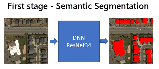
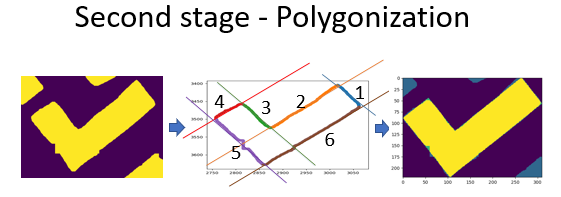
We remove noise and suspicious data (false positives) from the predictions and then apply a polygonization algorithm to detect building edges and angles to create a proper building footprint. The entirety of the new batch of USA building footprints has been processed with these techniques, which makes them great candidates for development and social projects.
Creating building footprints
We’re familiar now with how image processing techniques like polygonization create a sharper final output, but where is the imagery actually sourced from? Truly reliable building footprints need high-resolution imagery as a foundation.
In this case, Microsoft’s new set of building footprints uses Bing Maps API’s rich location data as a base. This data is captured through powerful aerial cameras with resolutions as high as 60cm-30cm/pixel, making it one of the highest quality imaging platforms in the world.
Deep neural networks, machine learning, and sampling layers are then applied to this imagery to identify key map features like buildings.
Developer-friendly footprints
There are multiple ways to access Microsoft’s new set of building footprints because they are open source. While developers can download and use them through GitHub, Bing Maps API also allows for native calls through a REST service. This is enabled by the Imagery API which facilitates the use of static maps and imagery metadata in mapping apps.
All we need to access USA building footprint data is a simple URL template — many of which are readily available in our Imagery API documentation. Here’s an example of what a typical request might look like for a location in Seattle:
https://dev.virtualearth.net/REST/v1/Imagery/Map/Road/47.645523,-122.139059/18?mapSize=500,500&pp=47.645523,-122.139059;66&mapLayer=Basemap,Buildings&key={BingMapsKey}
This request will call Microsoft’s Imagery API for a road map with building footprints at a specific zoom level. This can be adjusted depending on the developer’s needs. The building footprints are added as a layer through the mapLayer=Basemap,Buildings parameter. The Imagery API offers a variety of different types of imagery such as aerial and streetside, which creates multiple exciting new use-cases for these building footprints. OpenStreetMap, for example, uses aerial imagery rather than road maps for building footprints.
And that’s it! With a single template and parameter, we can access building footprints for a given set of coordinates.

Using this approach we extracted 129,591,852 footprints in the United States. In OpenStreetMap there are currently 30,567,953 building footprints in the US (the last time our team counted) both from editor contributions and various city or county wide imports. Bing Maps is making this data available for download free of charge.
Create a Bing Maps API key to discover further applications of our location data, and get started with a developer-friendly mapping experience today.
FAQ
How can this data be used?
This set of building footprint data for the USA is useful for a range of different applications. Having an accurate map of rural and urban development is a necessary condition for effective long-term state planning, and can save precious time and resources that would otherwise have been used for surveying remote areas.
One of the most popular applications of building footprint data has, however, been seen in OpenStreetMap. The Humanitarian OpenStreetMap Team is effectively crowdsourcing the identification of potentially vulnerable areas with the use of building footprint data. Once identified areas are mapped and verified, humanitarian organizations can act quickly in times of need.
What format is the data stored in?
Microsoft’s building footprint data is easily accessible in the GeoJson format, which is commonly used to encode a range of different geographic data. This file format has been chosen due to its compactness relative to other XML formats, as well as its easy readability. For example, here’s a GeoJson file with New York as a reference point.
{
    "type": "FeatureCollection",
    "features": [
      {
          "type": "Feature",
          "geometry": {
              "type": "Point",
              "coordinates": [-74.006393, 40.714172]
          },
          "properties": {
              "name": "New York",
              "description": "New York"
          }
      }
    ]
}
Is the data accurate?
Yes, with the data being put to use in humanitarian projects and planning, the building footprint data is ready for use from the get-go. Additionally, our polygon evaluation metrics, which are tools for measuring the quality of imaging data, report values of 98.5% and 92.4% for precision and recall respectively.
You can read more about this work and directly download the data from GitHub. The CNTK toolkit developed by Microsoft that was used to derive these building footprints is open source and available on GitHub along with the ResNet3 model at GitHub.
Our Bing Maps computer vision team will be presented this work at the annual International State of the Map conference in Milan, Italy.
- Bing Maps Team
