
NOTE: An updated version of this article can be found in the Microsoft Maps Blog.
https://www.microsoft.com/en-us/maps/news/geocoding-and-routing-improvements-added-to-bing-mapsGeocoding and Routing are core services in mapping platforms. Today, the Bing Maps team is happy to announce improved geolocation algorithms and increased coverage support for these services, which also directly improve the coverage of many of the new Bing Maps Fleet Management APIs, such as the Isochrone and Distance Matrix APIs which rely on routing data.
Geocoder Improvements
The Bing Maps team has spent several years developing a new backend geocoder, which provides improved matching logic and the ability to make faster data updates. This new geocoder went into production earlier this year, and the Bing Maps developer APIs were seamlessly updated on the backend, thus instantly migrating all users to the new geocoding platform without any code changes required by them.
In addition to creating a new backend geocoder, the Bing Maps team has been working hard on increasing the support for geocoding and geolocation globally. Bing Maps API ranks the level of geocoding support for each country using the following criteria:
- Rooftop – Addresses are resolved to the latitude/longitude coordinate at the center of the address parcel (property boundary). Rooftop has the highest level of accuracy support. Its coverage varies by country.
- Address – Addresses are interpolated to a latitude/longitude coordinate on the street.
- Street Name – Addresses are resolved to the latitude/longitude coordinate of the street that contains the address. The address number is not processed.
- Basic – Geocoding support is limited and primarily only accurate to the city level. If an address is valid, Bing Maps attempts to resolve it, but a result is not guaranteed.
The number of countries in which Bing Maps location API and geocoding platform has rooftop or address level detailed coverage has grown from 82 to 109 countries.
| Highest Level Support | # of Countries | |
| Old Coverage | New Coverage | |
| Rooftop | 17 | 46 |
| Address | 65 | 63 |
| Street Name | 12 | 46 |
| Basic | 159 | 98 |
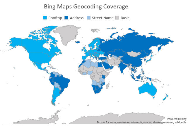
Detailed geocoding coverage information can be found here.
Batch Geocoding
The Bing Maps API geocoding platform’s ability to convert addresses into accurate geographic coordinates for geolocation is crucial for many small-scale operations, but what happens when you’re working with multiple locations at the same time?
One of the biggest strengths of Bing Maps API as a mapping platform is batch geocoding and reverse geocoding support. Now, organizations can convert thousands of addresses into coordinates and vice versa within minutes, all in one go. Of course, developers could always break the job down into multiple API requests, but that can quickly become a time-consuming process.
These improvements were enabled with the help of Bing Maps API’s Spatial Data Services, a powerful REST API that efficiently stores, processes, and geocodes data. Get a deeper look at batch geocoding with the Bing Maps API platform in our blog.
Routing Service Improvements
Bing Maps API provides geolocation and routing for the following modes of transportation: cars, trucks, walking and public transit. the API provides both real-time and predictive traffic based routing. The team is constantly tweaking and improving the algorithms and data to provide more efficient and accurate routes. These benefits and services can be leveraged in your own applications and web sites through the Bing Maps for Enterprise Routing APIs. Bing Maps API ranks the level of routing support for each country using certain criteria, similar to geocoding support:
- Good - The country/region has detailed road data available in most populated centers and most of these have been verified for accuracy. Coverage is updated frequently. Remote areas may lack some road information.
- Fair - At a minimum, the country/region has major road data available as well as some detailed road data. Most often, these roads have not been verified for accuracy. Coverage is updated over time. Please visit the map to assess if the current version meets the needs of your application.
- Major Roads Only - At a minimum, the country/region coverage includes major roads. These roads have not been verified for accuracy. Coverage is updated over time. Please visit the map to assess if the current version meets the needs of your application.
Just like our platform’s support for geocoding, the number of countries in which Bing Maps API has good routing coverage has grown from 58 to 116 countries. This growth goes hand-in-hand with similar updates to Bing Maps API’s geolocation and location intelligence capabilities
| # of Countries | ||
| Old Coverage | New Coverage | |
| Good | 58 | 116 |
| Fair | 82 | 54 |
| Major Roads Only | 113 | 83 |
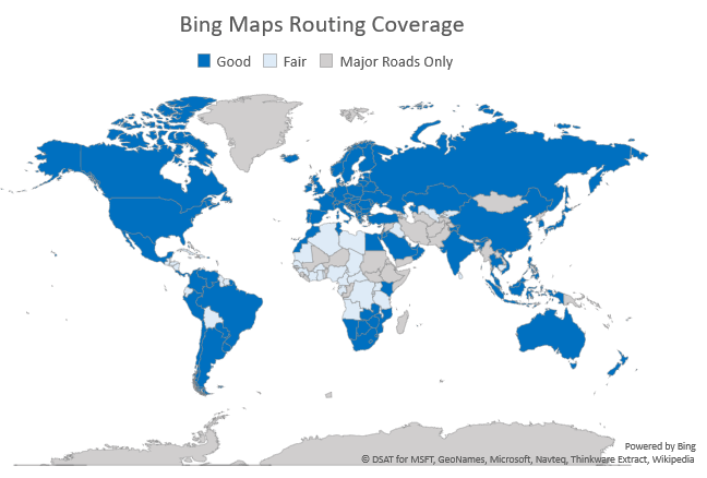
Detailed routing coverage information can be found here.
Truck Routing
Batch geocoding identifies the right place and Bing Maps API’s routing capabilities understand that not all roads are built the same, therefore a reliable routing solution has to account for highly variable factors like vehicle size and road dimensions. Our Truck Routing API can account for these factors and provide an optimized navigation solution that keeps commercial considerations in mind.
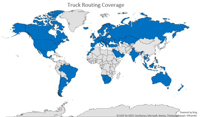
Truck routing geolocation support was recently added to Bing Maps API and is supported in 80 countries. With support for snap-to-road and predictive traffic, truck routing is up there with geocoding as one of the platform’s most practical features for dynamic organizations.
Detailed truck routing coverage information can be found here.
Case Use: Routing With Maplytics
For a look at our improved truck route mapping and geocoding in action, check out our Maplytics customer story! Inogic built Maplytics using Bing Maps API and other Microsoft services to create a comprehensive platform that could geocode and analyze geographic data. The team also incorporated the Truck Routing API to add route planning features for their users.
Maplytics’ smart solution for routing can serve multiple agents working complex routes, while still accounting for unique details like vehicle height, axle numbers, and turn radius. Creating immersive geolocation experiences that scale for organizational use is easy with Bing Maps API. Create a Bing Maps API key, consult developer resources for tips, and you’ve got everything you need to build a powerful map app.
If you have any questions about geocoding, routing or feedback about Bing Maps API, please let us know on the Bing Maps forums or visit the Bing Maps website to learn more about the Bing Maps platform.
- Bing Maps Team
FAQ
How do I get started with geocoding with Bing Maps API?
The best place to start for a beginner to geolocation is Bing Maps API’s Geocode Dataflow API documentation. You’ll find everything you need to get started with geocoding and reverse geocoding. Keep in mind that there are currently two data schema versions on the platform, with V2.0 offering more geocoding data in each response.
Are there any limits to geocoding?
There are varying geocoding limits in place depending on which Bing Maps API platform key you’re using. Basic key users will be limited to 2 jobs in process at the same time and a 50 job limit over a 24 hour period. Learn more about key limits in our geocode limits documentation, as well as our maps API licensing options.
How can I add truck routing to my app?
Adding truck routing, itinerary optimization, and other geocoding features to your geolocation app is easy with Bing Maps API’s V8 Web Control. You’ll be able to develop apps for a variety of platforms while still retaining features like high-res imagery and truck routing. Check out the interactive SDK for a quick way to get started
