
Today, we are pleased to announce the release of three new Fleet Management APIs – Truck Routing, Isochrones, and Snap-to-Road – all available with the Bing Maps V8 Web Control and REST services. These APIs are the latest additions to our Fleet Management collection, which includes the Distance Matrix API that was announced last month.
Let’s dive into the details.
Truck Routing API
Bing Maps Truck Routing API calculates routes optimized for trucks and commercial vehicles. The routes include information such as route instructions, travel duration, and travel distance. The API takes into consideration specific requirements for trucks and larger vehicles (e.g., avoiding low bridges, sharp turns, steep gradients, or following restrictions and permits for hazardous material).
Commercial vehicles have specific transportation requirements. Oftentimes using consumer routing services, made for cars and other consumer vehicles, is not the best solution. Routes tailored to commercial vehicles can help avoid a number of unhappy and potentially dangerous situations, not to mention increase efficiency, ensure compliance with legal restrictions, and help customers realize potential savings on fuel costs, vehicle maintenance, and fines.
For example, the red route in the screenshot below uses a consumer routing service, whereas the green route takes into consideration the height of the truck and routes you around a low-clearance bridge. In addition, the Streetside imagery capabilities of the Bing Maps platform allow you to see why your vehicle needs to take a different route (e.g., low or narrow bridges, tight corners, sharp inclines, waterways, and more).
With the Bing Maps Truck Routing API, you can set the following parameters and preferences for your vehicle’s attributes to calculate a safe route that takes into consideration certain road and legal restrictions:
- Vehicle’s dimensions and weight
- Number of axles and/or number of trailers
- Speed limitations
- Legal restrictions and permit requirements, such as transporting flammable materials
- Road conditions (strong crosswind areas, construction, road gradient, etc.)
- Avoid route, such as toll roads, highways, ferries, and more
Isochrone API
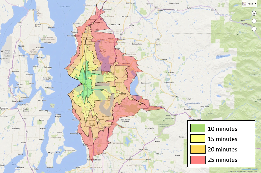
The Bing Maps Isochrone API calculates the area that can be travelled to within a specified distance or time and renders a travel time or distance polygon to visualize the shape of that area on a map. Use this API to plan the area that can be reached from a designated starting point within a set time period.
For example, in a job hunting scenario, you may want to see office locations that are within a 10, 15, 20 and 25 minute-drive from your home (as shown in the screenshot below). In that case, a time-based search will provide a visualization of the area, using predicative traffic to help you determine your potential commute time.
The polygon area can also be used to filter for spatial queries. In a commercial real estate use case, the Isochrone API can help with site selection where you want to see how many of your competitors are within a 10-minute walk or drive of a potential new store location.
Below is an overview of the Isochrone API features that can help you easily optimize planning:
- Travel-time or Travel-distance isolines
- Modes: Walking, driving and public transportation
- Avoid routes, such as bridges, ferries, or tolls
- Supports multiple polygons to determine intersecting area
- Customizable parameters: Supports arrival or departure times (reverse flow) predicted traffic, user’s location, and more.
Snap-to-Road API
The Snap-to-Road API takes GPS point data, in the form of latitudes and longitudes, and returns a list of objects that form a route snapped to the roads on a map. The information returned on the road segments includes the names of the roads that the GPS points are associated with and their posted speed limits. With a maximum number of 100 points per API call, the API can easily support multi-stop route use cases.
Users can also request that the points be interpolated, resulting in a path that smoothly follows the geometry of the road. In the screenshot below, the blue pins represent the input coordinates, and the red line is formed by the snapped points in the response with the speed limits displayed.

How does it work? GPS points are not always exact, so the API converts the GPS points of your tracked assets to a corresponding set of interpolated latitude and longitude coordinates of the nearest roads. This feature is important when tracking assets, as GPS devices can lose their connection or encounter interference resulting in an incomplete or inaccurate collection of GPS points. Tracing GPS points, otherwise known as historical bread crumbing, can be used for post-drive analytics or in real-time asset tracking. The algorithm that powers the Bing Maps Snap to Road API is based on this great paper written by Microsoft Research.
You can also use Bing Maps V8 Web Control to display the interpolated points on a map as a route line that nicely follows the geometry of the roads, as shown in the image above. The Bing Maps V8 Web Control Infobox feature can also be used to display information about each GPS point (e.g., truck number, driver’s name, street name of the road, posted speed limit, and driver’s speed).
Get Started
For more information about each of the APIs, including documentation, how to get licensed, and frequently asked questions, visit our website.
We hope you will enjoy using these APIs as much as we’ve enjoyed building them. As always, we are open to your feedback. Connect with us on the Bing Maps Forum to share your thoughts and let us know what you would like to see in future versions.
- Bing Maps team
