Smart Sales Territory Management using Maplytics and Microsoft Dynamics 365 CRM!
Are you a Manager who wants a permanent solution for your sales reps that unknowingly act on each other’s Leads? Do you have clients outside of convenient travel areas making scheduling visits a challenge? Is your company looking to branch out sales beyond your current zone but are unsure of how to build the logistics infrastructure required for such expansion? Well then, the common solution to your woes lies in defining Sales Territories!
Defining Sales Territories
Targeting markets in a country, state, county, city or any defined region can be acomplished with well defined sales territories. Existing customers can be served and new potential clients can be easily entered into Microsoft Dynamics CRM. As an example of defining a sales territory, let's consider the state of Texas. The state of Texas is famous for how large and rural it is, but also having some densely populated cities. A company would need to hire the right number of sales reps to look after their customer needs. Sales Territories would need to be defined to balance workload and travel required. Once these territories are defined, sales, revenues, client servicing, and new lead generation of those territories would become the responsibility of the sale representative for that territory, clearly defining ownership and avoiding misunderstanding. The process of territory management is a dynamic one as customer locations grow, territories can be added and resized to accomodate.
Benefits of Territory Management
- Visualization of Sales Territories worldwide on Bing Maps from anywhere around the world
- Easy assimilation of new Clients and formation of new Territories
- Quick rephrasing of existing Territories with changing conditions
- Distributed workload among authorized and allotted personnel
- Better attendance to Client requirements
- Established Work-Life Balance for the Users, etc.
Territory Management using Maplytics within Microsoft Dynamics 365 CRM
Territory Management within Maplytics leverages Bing Maps for Enterprise to be Innogic's best-selling and most in-demand feature across industries. Client records and potential leads from CRM are plotted over a Bing Map to easily identify areas requiring sales coverage. Maplytics offers the ability to define territories using excel/shape files, regions, existing territories, overlays, or even just by drawing shapes on the map using the drawing tools.
Once created, existing territories can be refined as needs change, such as addition of new clients, for efficient management with changing market conditions. When new markets are discovered, they can easily added to the existing ones while maintaining a balanced workload among all territories.
Managing Territories with Maplytics within your CRM
Plotting & Viewing Territories
Users of the Territory Management option of Maplytics can create multiple territories automatically based on the count of records or use the Territory Alignment tool to select the required regions and create new territories. While creating multiple territories automatically, they can also save the created territories as ‘drafts’ and rework these drafts to later get the territories created as per the requirement and convenience. This gives time for discussion and proper decision-making.
There are also search options available to plot shape files, excel files, search by region, draw a shape, or plot existing territories on the map. These features allow extra flexibility in creating territories as the user can manage to create balanced territories without being restricted to the city, town, or postal boundaries. There are five available search options:
File |
Plot shape files and excel files on the map that stores geographical information and attributes of the geographic features. Users can plot the following two types of files:
|
Region |
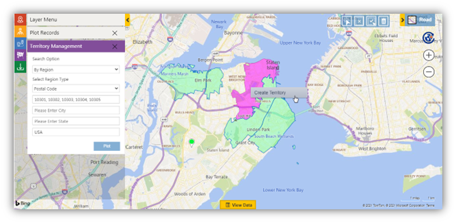
Search for regions on the map by City, State, County, Country, PostalCode, PostCode Sector, PostCode(Outward Code), and PostalCode Area. |
Drawing |
Draw a shape on the map using the Drawing Tool Bar. The drawing gives complete control to the Users to mark a flexible territory as per preference beyond the limits of cities, towns, countries, etc. |
Territory |
Plots existing, pre-created territories on the map to visualize them for their expanse, coverage, and other intricate details |
Overlay |
Select any shape/excel file saved in CRM to plot the same on the map. Users can also select an attribute within ‘Category Attribute’ to categorize the regions plotted on the map. Also, they can select one or more attributes within ‘Summary Attribute’ to show on the Summary card when clicking on any region plotted on the map. |
Creating & Managing Territories
Maplytics customers can create territories manually or automatically based on a shape/excel file and leverage the count of records plotted on the map to get the desired number of balanced territories. Auto creation can save a lot of time if a business needs to create a high number of territories in multiple regions involving many minute details.

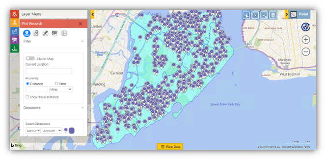
The user can then, go to the ‘Plot Records Card’ and select the required ‘DataSource’ and the respective ‘View’ to plot the same on the map. These records will be distributed among the territories that are to be created.

Using the options ‘Select’ or ‘Multi-select’ from the ‘Alignment Tool’ the required regions and right-click to select the option of ‘Create Territory’ to open the window. Here, the user can select the option to ‘Create Multiple Territories’ and enter the number of territories they want to create out of the selected regions on the map.
.png)
If further work on the territories is needed or they are not ready to commit the new territory definition, they can choose ‘Save’ from the Actions and save the territories processed as ‘Draft territories’ within the CRM.
.png)
Once they are created, boundaries of the drawn shapes can be modified. Microsoft Dynamics 365 also supports hierarchy of territories to manage multi-level territories. If an organization has enabled ‘Hierarchical Territoriesrsquo; in CRM, they can plot and manage territories within larger territories. Any child territories created for the selected parent territory will also get plotted on the map when the parent is selected.
This is great but is there more?
Apart from Territory Management, Maplytics has developed many helpful features using Bing Maps for Enterprise services like radius search, optimized routing with turn-by-turn navigation and along-the-route, Appointment Planning, Truck Routing, Tracking Field reps with Real-Time Tracking, performance analysis of complex data with Heat Maps, Census Data and shapefile overlays amongst others.
To learn more about Maplytics, its applications across industries, and another multitude of features, do visit our Website or the Microsoft AppSource. For further details, you can hop on to our Blogs, Client Testimonials, and Video Library.
Team Maplytics

