
We in the GIS and LBS world have long wondered how it would be possible to create such a mapping engine that would render the most accurate, up to date maps available with roads and points of interest, geographic boundaries, etc., etc. Let’s put geopolitical issues aside (or not) and in our heads we’ve all considered this open map system which allows users to contribute to a wiki of sorts to create maps of their respective areas where there are experts and have the data readily available. The concept is coming closer to reality with OpenStreetMaps which allows you to contribute to the creation of what may become a serious repository of location information inclusive of all the data we the world need to improve the scale and accuracy of mapping out the world in order to use it as the canvas in which we paint our information for data visualization. The interface for this has been challenging, but with Virtual Earth and imagery contributions from Bing Maps it seems the time is right for just such an experiment to get us a step closer to geospatial Shangri-la.
Bing Maps Spatial Data Services
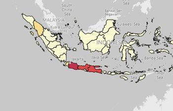 |
Indonesian Province Census Map This sample shows how to create a simple choropleth map which retrieves boundary data from the GeoData API in the Bing Spatial Data Services. | |
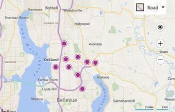 |
Find Nearby Search using the Query API This sample shows how to do a nearby search using the Bing Spatial Data Services Query API to find gas stations that are within 25km of the center of the map. | |
 |
GeoData Choropleth Map This sample shows how to create a simple choropleth map which retrieves boundary data from the GeoData API in the Bing Spatial Data Services. |
Open Street Maps Data
OSM allows you to search through the current repository of user contributed data. You can submit modifications and additions to data that exists today and these will be reviewed by volunteers. To try OSM, go to https://www.openstreetmap.org/ and to find out more, check our their "about" page at OpenStreetMap/about
Pulling it all together
Spatial Data is very much the key to all things related to location intelligence. On Bing Maps in that you can display your collection of points, polygons and lines in the Spatial Data Service cloud and search on them. An excellent example is our StoreFinder sample which places "Contoso Coffe" and "Fourth Coffee" locations in a Bing Maps Data Source and then displays the locations closest to you when you need a fictitous cup of coffee. Collections of such data, even public ones like our Census and Points of Interest Data play a part to help derive knowledge from other spatial data when they are mixed.
